FreeOZ论坛

标题: ....... [打印本页]

作者: Viola    时间: 3-1-2010 23:31
标题: .......
.......

[ 本帖最后由 Viola 于 27-12-2011 22:33 编辑 ]
作者: stellahie    时间: 4-1-2010 00:22

作者: 千叶百合lily    时间: 4-1-2010 09:30
原帖由 Viola 于 4-1-2010 00:34 发表
经过在空中无聊地盘旋1个小时,半夜无辜地开去蓝山一趟,现在终于在家了。。。游记、照片慢慢奉上


亲爱的,有啥艳遇不?哈哈哈
作者: cello    时间: 4-1-2010 10:47
16 days in southern island sounds good, waiting
作者: stellahie    时间: 4-1-2010 12:36
原帖由 cello 于 4-1-2010 11:47 AM 发表
16 days in southern island sounds good, waiting


cello上次你玩了几天,玩遍南北岛了吗?
作者: cello    时间: 4-1-2010 13:10
原帖由 stellahie 于 4-1-2010 12:06 发表


cello上次你玩了几天,玩遍南北岛了吗?

1 month, 1 week for north island (not enough time), 3 weeks for south island (better, with a campervan, no need to worry about where to sleep thus more time to drive around)
作者: storming    时间: 4-1-2010 19:39
再不上照片就坑你!
作者: stellahie    时间: 4-1-2010 19:46
原帖由 cello 于 4-1-2010 02:10 PM 发表

1 month, 1 week for north island (not enough time), 3 weeks for south island (better, with a campervan, no need to worry about where to sleep thus more time to drive around)


估计北岛一周你也跑不了多少地方,Cape Reinga去了吗?
作者: milanmengxiang    时间: 4-1-2010 22:35
蹲坑等作业
作者: Dreamhouse    时间: 4-1-2010 23:04
我还在等哦!!!!!!!
作者: 傻狼    时间: 4-1-2010 23:07
标题: 咋这么多坑啊!!你不越野你也刨坑啊?

作者: 生命如此欢喜    时间: 6-1-2010 18:27
挖坑不填好像不是V版的风格哦
作者: stellahie    时间: 6-1-2010 18:51
我等到花儿也谢鸟
作者: ozbird    时间: 6-1-2010 19:16
原帖由 stellahie 于 6-1-2010 19:51 发表
我等到花儿也谢鸟

谢我干嘛?
作者: 老顽童    时间: 6-1-2010 21:05
光只有坑啊!月球?
作者: Dreamhouse    时间: 6-1-2010 21:16
对了
最近忙什么?
楼主。
作者: y2kgo    时间: 7-1-2010 21:46
好漂亮哦
偶也想去新西兰

作者: lovesunshine    时间: 7-1-2010 22:09
自由的行走真好
作者: 生命如此欢喜    时间: 8-1-2010 00:16
好美哦,下一个目标---新西兰
作者: flyday    时间: 8-1-2010 01:29
多点雪多点灵气
生命在行走中延伸
作者: atraveller    时间: 8-1-2010 08:19
Wow, that tree! I don't remember it looks that stunning when you took a shot. Waiting for more to come.
作者: lymmd    时间: 8-1-2010 13:09
期待下面的图文,顶一下!
作者: ozbird    时间: 8-1-2010 21:21
如果光缩小不进行其他处理的话,用acdsee就挺好,可以批量缩小,一下子把所有想缩的都缩了。
作者: ozbird    时间: 8-1-2010 21:40
原帖由 Viola 于 8-1-2010 22:25 发表


光影也可以批量缩。现在的问题是缩完之后质量大幅度下降,不知有没有办法解决


质量大幅度下降是没设置好吧?
作者: boblee    时间: 8-1-2010 23:05
标题: 搬个板凳学习学习
再过2周俺也出发去NZ了
作者: eva_kong    时间: 9-1-2010 00:18
幸福的人
作者: milanmengxiang    时间: 9-1-2010 20:44
宁静而又深邃的风光,感觉和澳洲很不一样,也许是习惯甚至麻木了悉尼的喧嚣了吧。。。。。。很期待NZ
作者: ozbird    时间: 9-1-2010 22:42
原帖由 milanmengxiang 于 9-1-2010 21:44 发表
宁静而又深邃的风光,感觉和澳洲很不一样,也许是习惯甚至麻木了悉尼的喧嚣了吧。。。。。。很期待NZ


其实在悉尼也能找到不少不那么喧嚣的地方,就看想不想找了。不过澳洲和新西兰的风光的确有很大差别,地质和气候等都有差别。
作者: y2kgo    时间: 9-1-2010 23:04

偶也要去~~~
作者: stellahie    时间: 9-1-2010 23:07
去过了,差点没被烤焦,热死了那天。

人多多多。。。
作者: 千叶百合lily    时间: 11-1-2010 08:31
亲爱的,我在你的带领下,目前不断地在户外烧钱。装备越买越多。
……
看到你这美丽的图片,似乎新西兰我也得去看看了……
银子啊,总是在不经意中就灰飞烟灭~~~~~
作者: ozbird    时间: 11-1-2010 08:35
原帖由 Viola 于 10-1-2010 22:15 发表
而山谷里的烟,像不像西游记里妖怪出没的地方?
95776 95777 95778


好像我每次出远门都能遇到白骨精
作者: ozbird    时间: 11-1-2010 08:46
原帖由 Viola 于 10-1-2010 22:04 发表
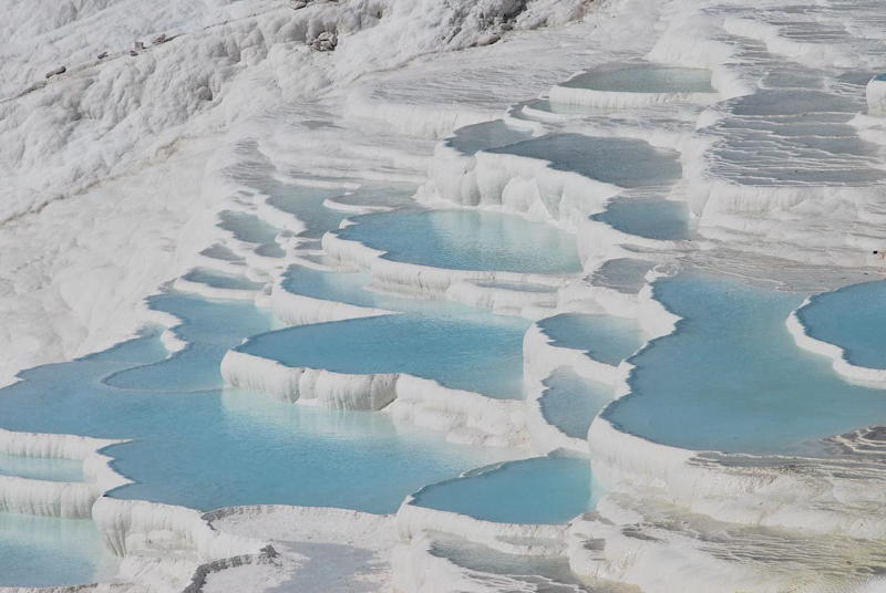
越过毛利人舞台,来到了一小片清澈的水滩,阳光照射下,有种世外桃园的感觉。
95753  走到TERRACES,像极了土尔基的棉花堡和云南的白水台,不同的是这里冒着丝丝白眼,水是滚烫的。与Waiotapu Thermal Park相隔不远 ...


温泉和石灰石共同形成的钙华。看起来和棉堡、黄龙与白水台真是很像。新西兰还有个类似的不错的地方1886年被火山活动毁掉了,从过去画家的作品看那里是挺漂亮的。

                               
登录/注册后可看大图


再来几张网上找到的棉堡的照片比较一下

                               
登录/注册后可看大图


登录/注册后可看大图


登录/注册后可看大图


登录/注册后可看大图


登录/注册后可看大图


[ 本帖最后由 ozbird 于 11-1-2010 09:56 编辑 ]
作者: MillerYang    时间: 11-1-2010 17:33
占个座慢慢欣赏
作者: stellahie    时间: 11-1-2010 17:33
下来到Taupo了吗?
作者: 老毒物    时间: 11-1-2010 18:53
景色美得没话说,
技术好得没话说,
美女有才得没活说
只有加分的份儿了
作者: stellahie    时间: 11-1-2010 18:55
原帖由 Viola 于 11-1-2010 07:30 PM 发表


TAUPO去完啦,猜猜下面要到哪?


我猜你们下来去走了Tongariro Alpine Crossing
作者: stellahie    时间: 11-1-2010 20:22
标题: 回复 #76 Viola 的帖子
不是,Taupo往南就是Tongariro NP了嘛,加上你说过有重头戏。
作者: Dreamhouse    时间: 11-1-2010 20:28
新西兰真是比我想像中美呢

我等着搬到澳洲再去
因为以后澳洲去哪里都好远啊!

呵呵呵
作者: stellahie    时间: 11-1-2010 21:08
标题: 回复 #79 Viola 的帖子
西南
作者: Jessie_Yin    时间: 11-1-2010 22:08
标题: 回复 #62 Viola 的帖子
北岛比我想象中漂亮。
目前准备今年Easter去北岛玩,南岛已经去过了。
想请问北岛大概几天的行程比较合适呢?
作者: bushwalker    时间: 12-1-2010 07:11
原帖由 Viola 于 11-1-2010 23:46 发表
[惨遭抛弃]

其实,在到达终点前,本人还发生了些小状况。
话说GPS指示还有500米到达终点,我一扭头发现MT Ruapehu在另一个角度,加上落日的余晖,再加上山脚下的牛牛羊羊,煞是好看,而且路边已经很多人在拍这个 ...


walkie talkie is useful for communication. At least ours was very helpful in NZ.
作者: stellahie    时间: 12-1-2010 08:17
标题: 回复 #86 Viola 的帖子
GPS。。。 我可是玩了NZ三周从中学会看地图的。。。

等着看徒步大作!
作者: atraveller    时间: 12-1-2010 08:34
Dear, it was from 110~ 120km/h to a sharp turn recommeded at 25km/h, and faced that 那个咸蛋黄. Thanks to my tough nerve.

In waiting 2.
作者: ozbird    时间: 12-1-2010 08:44
原帖由 Viola 于 11-1-2010 23:27 发表


EASTER是秋天,不是应该南岛更漂亮吗?

我没怎么做功课,这次对北岛也是走马观花,ROTORUA的后两个景点是意外惊喜。而我认为北岛最值得去的是TONGARIRO ALPINE CROSSING TRACK,明天会写。不过,如果你不能徒 ...


没真实的比较过,不过我感觉南岛还是春天更好。因为南岛的卖点在雪山,而秋天是雪最少的时候。雪化了一个夏天了。而春天则是雪积累了一冬天,刚开始化,再加上有些花也纷纷开了。至于北半球那种菜叶缤纷的秋景,新西兰虽然也有,但都是外来植物而已。新西兰的本土植物都是常绿的,和澳洲一样(实际上整个南半球温带都是如此,秋季落叶的植物是从北半球温带发展起来的)。
作者: cello    时间: 12-1-2010 08:47
原帖由 Viola 于 11-1-2010 20:04 发表


相信秋天更美!这一路来我就一直念叨着一定要秋天再去一次,但前提是自己变成full license或者找个full license的伴,这个原因以后会提

no I don't think the autumn is better. yes the deciduous trees look good, but the snows on the mountain are almost all melt. without the snow and wild flowers it's a bit boring IMHO. But maybe another advantage is less tourist, I find in general NZ is more crowded by tourists than most parts of AU.
作者: ozbird    时间: 13-1-2010 08:52
原帖由 Viola 于 12-1-2010 23:58 发表
春天啊?还没想过呢,光顾着想秋天了,还以为秋天的雪很多呢


秋天的雪怎么可能多呀?都是夏天下的吗?那估计有冤情了。。。。。
作者: Jessie_Yin    时间: 13-1-2010 10:15
标题: 回复 #83 Viola 的帖子
多谢建议!我也对ALPINE CROSSING TRACK感兴趣,据说是NZ最有名的one day track。

期待你的徒步大作。
作者: stellahie    时间: 13-1-2010 10:33
再不写,花儿又要再谢鸟了。
作者: ozbird    时间: 13-1-2010 21:58
原帖由 Viola 于 13-1-2010 17:49 发表


我没想到夏天会溶雪 只想到浓浓的秋色、皑皑的白雪和碧蓝的湖泊。。。原来是没有这样的结合的呀


其实这样的结合也是存在的。雪不会化光,有些是永久积雪。不过壮观程度自然不如积雪多的时候。而秋色在新西兰也不是主体,所以这样的组合虽然存在,但未必理想。
作者: cello    时间: 14-1-2010 08:40
我没有参加package,所以这段路没走完,走到那个硫磺湖以后原路返回,不然俺的房车就在几十公里以外了,所以一路没有看到任何的绿色,就像指环王里面那个glen说的,通往mt doom的路,石头,无数的石头。。。
作者: 我无聊    时间: 14-1-2010 09:26
非常美,谢谢分享!
作者: bushwalker    时间: 14-1-2010 10:30
原帖由 Viola 于 14-1-2010 01:14 发表
[Tongariro Alpine Crossing Track]
Tongariro Alpine Crossing Track号称新西兰最佳一日徒步路线,全长18.5KM,爬升1000米,下降1300米,需时7-9个小时。这里是详细介绍:http://www.tongarirocrossing.org.nz/
...


Yes, this is one of "nine" top tracks in New Zealand. You were so luck to finish this one.


NewZealand’s most popular tramping/trekking tracks and a river journey are collectively known as the Great Walks.

The "Nine" Great Walks were selected because of their popularity with both visitors and local trampers, and for their outstanding scenery. The Department of Conservation (DOC) has upgraded these tracks over recent years to well-marked bench tracks suitable for any person who is reasonably fit. Modern well-equipped backcountry huts and picturesque campsites are placed at convenient distances along the tracks, which take three to five days to traverse.

There are Three Great Walks in the NorthIsland. Lake Waikaremoana Track circles a beautiful lake in a mystical area of splendid isolation. Tongariro Northern Circuit crosses a moonscape of thermal vents around an active volcano.Whanganui River Journey is a fun-filled float trip by canoe, kayak or raft through spectacular gorges and exciting rapids.

The Six South Island walks offer an even greater diversity of scenery. Abel Tasman Coast Track is the most popular walk along gentle bush tracks and golden beaches. Heaphy Track passes through impressive limestone country and ends with amagnificent beach walk. Routeburn Track penetrates an alpineworld of high passes and towering peaks. Milford Track is the premier attraction, having earned its reputation as ‘the finest walk in the world’. Kepler Track has outstanding alpine, lake and river scenery. Rakiura Track on Stewart Island,which was opened in 2001, covers unspoiled forest and coastalscenery.

Hut and campsite passes need to be purchased before starting outon your trip. The three most popular ones, Abel Tasman, Milford and Routeburn have a booking system which guarantees a bunk for the night, but the others are on a first come first served basis. Bookings are heaviest in the summer season, particularly in January.

For the active visitor the Great Walks are the ultimate way tosee New Zealand’s natural environment at its very best.


I walked in Milford Track on Dec 7-10, 2006 with one mate, and this Dec 12-15, 2009 again with Circleyue. We had great time over there.

This time we saw one Belgian guy who was walking all six tracks in South Island of New Zealand within one month. He admired us very much as our flight ticket only costed about $350 (and NZ looks like courtyard of OZ for distance wise) while he spent over $3000 for flilght ticket only.

We are thinking to go to NZ every year to finish one or two tracks within ten days. We are planing to pick up Routeburn Track and Kepler Track near Queenstown region in Dec 2010.  Anyone who is keen to join is very welcome to join regular Sunday hiking (for 6-8 hours) around Sydney region and interstate in Australia.


Routeburn Track
Experience New Zealand's second most famous walk, which straddles the rugged spine of Fiordland's Humboldt Mountains, and enjoy scenery even more varied than theMilford Track.

The Routeburn Track has the capacity to lift you way beyond the normal world of outdoorexperience. It is utterly sublime. A gloriously remote and untouched wilderness pathway, that can lead you back from the 21st Century to view a pre-historic earth. The view from the track’s highest point, Conical Peak near Harris Saddle,holds you spell bound and lost for words. The panorama of encircling snow-capped mountains extends to the Tasman Sea. The exquisite serenity, stillness and loveliness of Lake Harris, will remain a permanent image etched in your mind.

The 33 km track usually takes3 to 4 days with a choice of 4 huts and 2 campsites that need tobe booked well in advance. The huts are located at Lake Howden,Lake Mackenzie, Routeburn Falls, and Routeburn Flats. The track can be walked from the Divide on the Te Anau/Milford highway, or from the Routeburn Shelter at the head of Lake Wakatipu.

The variety of landscapes isamazing. From the grassy river flats you climb through dense beech forest to the snowline where alpine plants grow in profusion. An exposed sub-alpine section is traversed on Day 2,following the Routeburn to its outlet from Lake Harris. The natural sounds of water tumbling, trickling, gushing and cascading can be heard all along the track. The vegetation grow this prolific, and you can see native birds and colourful butterflies along the way. Great Walk hut or campsite passes can be purchased at the visitor centres in Te Anau, Queenstown and Glenorchy. Public transport is available at either end of the track but needs to be pre-arranged.

The Routeburn is a one-offexperience. You will never forget the overwhelming accumulation of natural beauty and the endless variety of forms, shapes andcolours.

Kepler Track
Stroll on into Te Anau, ‘TheWalking Capital of New Zealand’, and set out on ourbest-planned Great Walk, which starts right on the edge of town.

The 67 km Kepler Track is the perfect complement to its nearneighbours, the Milford and Routeburn tracks. It combines all the best archetypal Fiordland features such as moss-draped beechforest, rich bird life, alpine tussock, mountain ranges,cascading waterfalls, glacial valleys, river flats and limestone for mations. Bookings are essential in the October-April walking season.From May the track reverts to the Backcountry Hut ticket system.Camping is only permitted at Brod Bay and near the Iris Burn Hut.

This 3 to 4 day tramp starts by hugging the southern shore of Lake Te Anau as far as the Waiau River Control Gates. From thereit is an easy walk to Brod Bay before tackling the 4 hour ascentto Mt Luxmore Hut. On Day 2 there is an option to explore thelimestone caves on Mt Luxmore, and climb to the summit (1,471metres) for a 360° panorama of Lake Te Anau and the Murchison Range. The native takahe bird was found in this range in 1948 after years of presumed extinction. From Mt Luxmore the track crosses an exposed alpine ridge for 12 km before descending through beech forest to the Iris Burn Hut.

On Day 3 the track winds down an ancient glacial valley to Moturau Hut on the shores of Lake Manapouri, from where it is a 2hour tramp to the Rainbow Reach exit. A regular shuttle service operates here in summer. Alternatively you can continue up the Waiau River to the Control Gates and back to Te Anau.

The Kepler Track is unique in its recent custom-made design as around trip route. Other New Zealand tracks evolved from Maoritrails or pioneer exploration routes.

This is the perfect place to have a hassle-free great outdoors experience at high altitude. The immensity and mountain splendouris simply breathtaking.


[ 本帖最后由 bushwalker 于 14-1-2010 11:31 编辑 ]
作者: cello    时间: 14-1-2010 11:06
the others are not day track though.

for those overnight tracks you need to register and pay to get a license. For me i still not use to pay for hiking, i still prefer more wild places rather than following other's footsteps.
作者: bushwalker    时间: 14-1-2010 11:19
原帖由 cello 于 14-1-2010 12:06 发表
the others are not day track though.

for those overnight tracks you need to register and pay to get a license. For me i still not use to pay for hiking, i still prefer more wild places rather than ...


Any interest driving to Cape York Peninsula from Sydney?
作者: ozbird    时间: 14-1-2010 11:23
去约克角半岛对车和越野技术的要求就高了,而且还有季节的限制。
作者: cello    时间: 14-1-2010 11:41
原帖由 bushwalker 于 14-1-2010 10:49 发表


Any interest driving to Cape York Peninsula from Sydney?

现在时间太少,这个没纳入日程。

从花费和兴趣的角度,我可能会更愿意先去PNG
作者: ozbird    时间: 14-1-2010 12:46
PNG是好地方,有些地方世界上也少有可比的,不过从安全性和自由性角度看不及澳洲内部的线路。当年PNG从澳洲独立,澳洲也不太想要这块地方。
作者: cello    时间: 14-1-2010 12:59
原帖由 ozbird 于 14-1-2010 12:16 发表
PNG是好地方,有些地方世界上也少有可比的,不过从安全性和自由性角度看不及澳洲内部的线路。当年PNG从澳洲独立,澳洲也不太想要这块地方。

自由性指得是什么呢?
作者: 才子    时间: 14-1-2010 13:21
哈哈,好漂亮的照片阿,谢谢美女带给我们的享受,你是玩疯了!
作者: cello    时间: 14-1-2010 13:53
原帖由 Viola 于 13-1-2010 23:50 发表
第二段急升,SOUTH CRATER TO RED CRATER
96327 96328 96329 96330 96331

我才看到图,这一路全是人啊。。 看来我秋天去也有好处,那条路线上一天看到大约有10个人左右吧,当时我还嫌多了呢

不过现在去山上的积雪还蛮多的,看起来漂亮多了
作者: ozbird    时间: 14-1-2010 14:02
原帖由 cello 于 14-1-2010 13:59 发表

自由性指得是什么呢?


我指的是澳洲到处都是旅游线路,而且比较成熟,基本上可以自驾去大多数想去的地方。而PNG则有很多地方并不方便去,或者可能跟团才比较好。
作者: cello    时间: 14-1-2010 14:16
原帖由 ozbird 于 14-1-2010 13:32 发表


我指的是澳洲到处都是旅游线路,而且比较成熟,基本上可以自驾去大多数想去的地方。而PNG则有很多地方并不方便去,或者可能跟团才比较好。

这些还好,就是绑架之类的有些吓人
作者: ozbird    时间: 14-1-2010 17:11
原帖由 cello 于 14-1-2010 15:16 发表

这些还好,就是绑架之类的有些吓人


那就是我说的另一个安全性的问题了。
作者: ozbird    时间: 15-1-2010 08:38
原帖由 Viola 于 14-1-2010 22:36 发表


弱弱地问一句,PNG是?因时间关系,我没去GOOGLE


巴布亚新几内亚
作者: cello    时间: 15-1-2010 08:46
原帖由 Viola 于 14-1-2010 21:05 发表


你是下了大斜坡再爬上去?强啊

and my parents and my uncle, who're over 60..
作者: anzbank    时间: 15-1-2010 17:24
快更新!!!!!
作者: cello    时间: 15-1-2010 22:28
原帖由 Viola 于 15-1-2010 20:07 发表


我要告诉李大厨,她有新偶像了!!

可能是有误会吧,没有你想象的那么强的。可能我们说的不是一个地方。我是指距离Red crater比较近的那两个硫磺湖,没到远处的蓝湖。然后我妈在后面,其实还没上到red crater,我回头了,感觉她上red crater也够呛,我就和她先下山了。
作者: cello    时间: 17-1-2010 22:14
原帖由 Viola 于 15-1-2010 22:51 发表


我看到你的照片已经照了那三个水坑 我说的大斜坡也就是下去那里的,我们说的是同一条路? 

我就是到那水坑而已,我走的时候是送石头路,脚能陷进去还不算很难,不那么滑。在那里还能看到远处有个大的湖,不冒气的,那个我没去。
作者: stellahie    时间: 18-1-2010 09:24
原帖由 Viola 于 17-1-2010 10:55 PM 发表
2009年12月23日,Wellington
今天离开TONGARIRO赶去WELLINGTON,准备明天一大早坐船去PICTON(南岛)。WELLINGTON是新西兰首都,风城。开头以为和堪培拉差不多,只是个政治中心,但想不到还挺热闹的,主街上应有尽 ...


作者: bushwalker    时间: 19-1-2010 19:57
finally you got the island we went
作者: stellahie    时间: 19-1-2010 20:55
偶们是从南岛到北岛,越接近Wellington风越狂。偶记得渡轮甲板那个风大啊 ,偶差点被吹走
作者: ozbird    时间: 19-1-2010 21:03
这么大风,会不会晕船呀?
3个小时倒是时间不长。
作者: cello    时间: 20-1-2010 08:48
picton,一个超级难找免费营地的地方。最后我在红十字会前马路边过了一个晚上,属于一路住的风景最差的一个晚上了。
作者: stellahie    时间: 20-1-2010 11:17
原帖由 ozbird 于 19-1-2010 10:03 PM 发表
这么大风,会不会晕船呀?
3个小时倒是时间不长。


一点感觉也没有,我还美美的睡了一大觉。
作者: stellahie    时间: 21-1-2010 00:12
标题: 回复 #151 Viola 的帖子
最美是接近/离开南岛Picton的时候,那个蓝哦。。。那部分醒着就行了。。。:)
作者: stellahie    时间: 21-1-2010 23:29
标题: 回复 #155 Viola 的帖子
你们走的哪条路去Greymouth,没经过西海岸的Punakaiki?
作者: stellahie    时间: 26-1-2010 22:58
去了Punakaiki之后几天我坚持早餐要吃pancakes。
作者: bushwalker    时间: 27-1-2010 09:54
原帖由 Viola 于 26-1-2010 23:26 发表
98530

98531

98532

98533


Perfect weather for your stay, Have you seen "What do you see?"
作者: bushwalker    时间: 29-1-2010 22:09
原帖由 Viola 于 29-1-2010 23:03 发表


没明白你想问我什么啊?


that is what I asked
作者: stellahie    时间: 29-1-2010 22:19
原帖由 Viola 于 29-1-2010 11:03 PM 发表


没明白你想问我什么啊?


有一组石块叫What do you see,你错过啦?
作者: stellahie    时间: 29-1-2010 22:21
原帖由 Viola 于 29-1-2010 11:05 PM 发表
[雪山下的灯光]
天气预报告知我们,南岛将在我们到冰川的那天开始下雨。。。而事实上,我们从小大洋路一直往FRANZ JOSEF开,云层就越来越厚,但我们还是抱着一丝希望,希望明天能天晴,我们能顺利HELI HIKE(就是坐 ...


为了那个Heli Hike,下次我还要去Franz Josef,不甘心啊。
作者: stellahie    时间: 29-1-2010 22:44
原帖由 Viola 于 29-1-2010 11:27 PM 发表


要不,下次咱们找一个星期,就住到FOX GLACIER去,就等那一刻!!


等不到就不回来了,tnnd。
作者: stellahie    时间: 29-1-2010 22:48
标题: 回复 #173 Viola 的帖子
Lake Matheson吗?
作者: stellahie    时间: 29-1-2010 22:54
标题: 回复 #177 Viola 的帖子
http://www.lakematheson.com/

是不是停车场有间Matheson Café,旁边有片牧场,有几头牛牛?徒步走完要一圈要1-1.5小时?
作者: bushwalker    时间: 29-1-2010 23:06
原帖由 stellahie 于 29-1-2010 23:48 发表
Lake Matheson吗?


Bad weather for us. We could not see anything over there.
作者: bushwalker    时间: 29-1-2010 23:08
原帖由 Viola 于 29-1-2010 23:57 发表


对D,应该就是那里了。不过我们刚走到湖,我正想往里走,因为风景实在不怎么样而且又开始下雨,所以没得到大家的同意继续向前,撤退了


This is a small world.
作者: stellahie    时间: 29-1-2010 23:19
原帖由 bushwalker 于 30-1-2010 12:06 AM 发表


Bad weather for us. We could not see anything over there.


我走完了。阴天,看了一些倒影,风景确实不咋样。


登录/注册后可看大图


我对牧场的牛牛还比较有兴趣,其中一只还被我吓得退着走。我有那么可怕吗?


登录/注册后可看大图

作者: stellahie    时间: 29-1-2010 23:23
原帖由 Viola 于 30-1-2010 12:12 AM 发表


天啊,又没明白

太晚了,脑子不好使了,睡觉去了


我猜bushwalker是说,我们走的路线都差不多,世界很小嘛。
作者: 千叶百合lily    时间: 30-1-2010 07:27
楼主好懒要打PP,这么久还没更新完……
加油加油!
作者: bushwalker    时间: 30-1-2010 16:14
原帖由 stellahie 于 30-1-2010 00:23 发表


我猜bushwalker是说,我们走的路线都差不多,世界很小嘛。


Quite right. Do not tell me you stayed at top 10 holiday park. We may stay at the same unit if so.
作者: bushwalker    时间: 30-1-2010 16:16
原帖由 Viola 于 30-1-2010 15:48 发表


可以想象只要有一点点阳光,这倒影会非常不错


Yes this is emotion to go back again in near furture.
作者: bushwalker    时间: 30-1-2010 16:18
原帖由 Viola 于 30-1-2010 00:12 发表


天啊,又没明白

太晚了,脑子不好使了,睡觉去了


We may stay at the same unit of top 10 holiday park over there (just one week early).

[ 本帖最后由 bushwalker 于 30-1-2010 17:21 编辑 ]
作者: stellahie    时间: 30-1-2010 16:40
标题: 回复 #189 bushwalker 的帖子
没有没有,我只在Waitomo那里住Top 10 Holiday Park。
作者: stellahie    时间: 30-1-2010 16:46
我们啥时候组织下一届啊?人家很想去哦。

我还要去~
1)Lake Tekapo - 看Church of the Good Shepherd。
2)Mt Cook Village - 去Sir Edmund Hillary Alpine Centre,晚上参加观星活动。
3)North & South Catlins - 从Cannibal Bay走到Surrat Bay。去Jack’s Blowhole,Cathedral Caves和McLean Falls。去Waipapa Point看灯塔。住2天农场,晚上数绵羊。
4)Milford Sound - 驾一趟The Milford Road,乘船到Milford Sound。
5)Glenorchy - 租一辆4WD,沿着无止境的Paradise Road一直走下去。
6)Franz Josef - Heli Hike去爬冰川。
7)Collingwood - 去Farewell Spit看水怪。
8)Wellington - 上Mt Victoria看风景。
9)National Park/Whakapapa Village - 花2天时间徒步爬山。
10)New Plymouth - 看火山。
11)Auckland - 再去以前住过的农场,探访农场主人一家,看看以我命名叫Stella的小羊长啥样了。
12)Whangarei - 看瀑布。
13)Paihia - 去北岛最北端的Cape Reinga和Ninety Mile Beach。
14)Kaikohe - 看森林,看树。
作者: bushwalker    时间: 30-1-2010 18:34
原帖由 stellahie 于 30-1-2010 17:46 发表
我们啥时候组织下一届啊?人家很想去哦。

我还要去~
1)Lake Tekapo - 看Church of the Good Shepherd。
2)Mt Cook Village - 去Sir Edmund Hillary Alpine Centre,晚上参加观星活动。
3)North & Sou ...


I am planing to go back south island of NZ for "Routeburn Track" and "Kepler Track" where are next to Milford Sound and Te Anau, repsectively.

In addition, I may pick up 1), 2), 4) (I strongly recommend Doubtful Sound), 5) (starting point of Routeburn Track), 6) of South Island if time permits.

Are you in Sydney this year? We could organise some actives before heading to NZ. My time is flexible.
作者: stellahie    时间: 30-1-2010 18:44
标题: 回复 #193 bushwalker 的帖子
Routeburn Track 32km,Kepler Track 60km 。 等我3月到悉尼去参加你们爬山帮的活动哈。

Doubtful Sound我去过了,住船上过了一夜。
作者: boblee    时间: 30-1-2010 21:04
快快更新,才过了一半时间啊
作者: boblee    时间: 30-1-2010 22:14
这个湖俺米有看到,估计在打瞌睡
作者: atraveller    时间: 30-1-2010 23:19
Happy to see you updated
from Bantanbang, Cambodia.


欢迎光临 FreeOZ论坛 (https://www.freeoz.org/forum/) Powered by Discuz! X3.2